


la feclaz

DaVinci
User
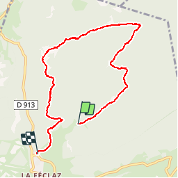

Length
8.2 km

Max alt
1393 m

Uphill gradient
106 m
Km-Effort
9.6 km

Min alt
1336 m

Downhill gradient
117 m
Boucle
No
Creation date :
2019-07-24 15:14:48.931
Updated on :
2019-07-24 16:57:50.185
1h42
Difficulty : Easy

FREE GPS app for hiking
 SityTrail
IGN / Geographical institutes
SityTrail Plus
The world is yours!
About
Trail Nordic walking of 8.2 km to be discovered at Auvergne-Rhône-Alpes, Savoy, Les Déserts. This trail is proposed by DaVinci.
Positioning
Country:
France
Region :
Auvergne-Rhône-Alpes
Department/Province :
Savoy
Municipality :
Les Déserts
Location:
Unknown
Start:(Dec)
Start:(UTM)
733160 ; 5059934 (31T) N.
Comments